Where Is Benin and What
Is It Known For?

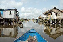
Canoeing through the stilt village of Ganvie in Benin.
|
Benin, officially the Republic of Benin, is in west Africa, on the Gulf of Guinea. It borders Togo to the west, Nigeria to the east and Burkina Faso and Niger to the north. Benin covers an area of approximately 110,000 square kilometers (42,000 sq mi), with a population of approximately 9.05 million.
From the 17th century to the 19th century, the land of current-day Benin was ruled by the Kingdom of Dahomey. The region became known as the Slave Coast during the early 17th century due to the prevalence of the trans-Atlantic slave trade. In 1892, with the slave trade banned and regional power diminishing, France took over the area and renamed it French Dahomey. In 1960, Dahomey gained full independence from France, bringing in a democratic government for the next 12 years.
Between 1972 and 1990, a self-proclaimed "Marxist-Leninist" dictatorship called the People's Republic of Benin existed, ushering in a period of repression which ultimately led to an economic collapse. During the 1980s, less than 30 percent of the population had access to primary health care services. Benin had one of the highest  rates for children under the age of five in the world. Its infant rates for children under the age of five in the world. Its infant  rate stood at 203 rate stood at 203  s for every 1000 live births. Only one in three mothers had access to child health care services. s for every 1000 live births. Only one in three mothers had access to child health care services.
Formation of the Republic of Benin occurred in 1991, bringing in multiparty elections.
The climate is tropical in the north, equatorial in the south. The economy is based mainly on agriculture and transit trade. Agricultural products account for two-thirds of export earnings. Oil, produced offshore, is also a major export.
|