Where Is Haiti and What
Is It Known For?

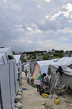
A young girl cooking outside her tent in on of the tent cities in Port-au-Prince, Haiti on August 28, 2010.
|
Haiti, occupying the western third of the Caribbean island of Hispaniola, is a mountainous state with small coastal plains and a central valley. The Dominican Republic occupies the rest of the island. The climate is tropical, and is hottest in coastal areas. The country's highest point is Pic la Selle, at 2,680 metres (8,793 ft). The total area of Haiti is 27,750 square kilometres (10,714 sq mi) and its capital is Port-au-Prince. French and Haitian Creole are the official languages.
Haiti has few natural resources, is densely populated and relies on exports of local crafts and coffee, and remittances from workers abroad. Haiti is the poorest country in the Americas as per the Human Development Index. It has experienced political violence throughout its history. Most recently, in February 2004, an armed rebellion forced the resignation and exile of previous President Jean-Bertrand Aristide, and a provisional government took control with security provided by the United Nations Stabilization Mission in Haiti (MINUSTAH).
On January 12, 2010, a 7.0 magnitude earthquake struck Haiti and devastated the capital city, Port-au-Prince. Although the exact number was difficult to determine, reportedly more than 230,000 people were killed. The Presidential palace, Parliament and many other important structures were destroyed, along with countless homes and businesses, leaving many homeless.
|